Our Laser4Snow project is following a pioneering approach to measuring snow density more accurately, faster and with fewer resources
The 21st century presents mankind with enormous challenges. Climate change will also have a lasting impact on Alpine landscapes. Precise and detailed knowledge of snow distribution in the mountains enables climate research to collect important data for forecasting the changes. Increasing global warming will influence precipitation and the melting of snow cover in the high mountains. Our project can provide valuable data for recording the water stored in the snow cover and, thus, also the expected amount of meltwater.
The Laser4Snow project is funded by the BMBWF as part of the "Sparkling Science" call.
![]()
![]()
The project consortium, consisting of the IFT of TU Wien, HTL Wien 10 and HTL Hollabrunn, would like to take this opportunity to thank you for the support you have already given us during the application phase. We will also receive significant scientific support from our partner Geosphere Austria.
Knowledge of snow density and snow layering is very important for glacier research on the one hand and for assessing the risk of avalanches on the other. In addition, precise knowledge of the snow density profile also enables a statement to be made about the amount of stored water. More precise and more data on the density distribution of extensive snow fields is therefore of great importance for many different users, such as climate research, tourism or power plant operators. Currently, snow density profiles are determined by digging vertical shafts, which involves a great deal of manual effort.
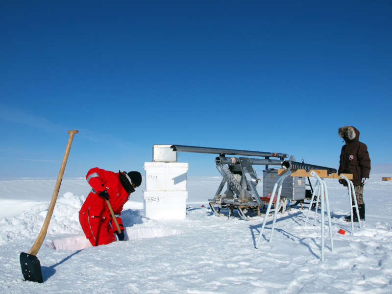 This work in the alpine environment is exhausting and measuring an extensive snow field therefore takes a lot of time, which is why there is usually little measurement data available. However, accurate data is of immediate importance for research. More and better data can contribute to a better understanding of the development of glaciers.
Data on the density distribution of a snowpack is also interesting for tourism, where more precise data can be helpful in more accurately assessing the risk of avalanches in certain areas.
In addition, the measurement of the density distribution can also be used to draw conclusions about the proportion of water stored in the snowpack. This snow water equivalent (SWE) of a snowpack is a decisive variable in hydrology, as it quantifies the potential runoff volume when the snow melts. The density of the snow, which largely determines the SWE, can be affected by strong spatial and temporal fluctuations due to processes such as wind redistribution and sublimation, melting and freezing, or even the absorption of rainwater. The spatial distribution of SWE is taken into account in hydrological models for the simulation of runoff processes, whereby the consideration of density gradients in the snow cover is of great importance. This will allow expected contributions from snowmelt in spring to be estimated more accurately.
As part of the planned Laser4Snow project, we would like to test a new method for measuring snow cover quickly and with little effort using lasers and set up a prototype measuring device. We will be supported by students from HTL Wien 10 and HTL Hollabrunn and receive scientific support from our partner Geosphere Austria.
We will use a combination of different laser sources to speed up the measurement process considerably and thus provide more and more accurate data in less time. One laser melts the snow and continuously drills down from above, while at the same time a second laser continuously measures the distance between the top of the snow cover and the current end of the borehole. This allows the melting speed and therefore also the snow density to be determined at any point above the thickness of the snowpack.
Apart from the adverse environmental conditions to which such a setup will be exposed, there are other challenges to overcome. The beam diameter of mobile laser sources - and therefore also the possible hole diameter in the snow cover - is usually only a few millimeters. The distance between the top of the snow cover and the end of the hole must be measured continuously through this narrow and deep hole. This rules out a number of conventional measurement methods, such as laser triangulation. We will develop a new measuring method in which the melting and measuring laser beams are guided together. To measure the borehole depth quickly, we will use a modified time-of-flight method and, with the help of students from HTL Wien 10, set up a complex optical measuring system to guide the laser beams together. We will be supported by the students of the HTL Hollabrunn for the continuous recording and evaluation of the measurement data. The prototype of the measuring system will be thoroughly tested and the limits of use of the measuring device will be determined. Our partner Geosphere Austria will significantly expand our knowledge of snow and the possible applications of the measuring device to be developed.
The Laser4Snow project is led by the Photonic Technologies research unit of the Institute of Production Engineering and Photonic Technologies.
Contact:
Diese E-Mail-Adresse ist vor Spambots geschützt! Zur Anzeige muss JavaScript eingeschaltet sein.
Diese E-Mail-Adresse ist vor Spambots geschützt! Zur Anzeige muss JavaScript eingeschaltet sein.
Offices:
Getreidemarkt 9
1060 Wien
Laserlab:
Franz-Grill-Straße 9, OY
1030 Wien